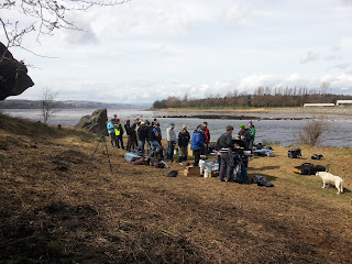
Well, it's all done folks, so no need to turn up on the Sunday. The weather was clement, the Council had strimmed back the brambles and we got amongst it, lifting litter, clearing fire pits, dumping old fences and carpets, rolling rocks, re-drifting driftwood, discovering odd items (satellite dishes, grit bins, lifebelts, the usual Inverclyde 'sharps' floating on the currents from across the water etc.)...
The effort was led by West Dunbartonshire Council's Linda Adam, the local Community Greenspace Office, and we were provided with rakes, high-viz vests, bin-bags, grabbers, gloves, pruners and a simply massive skip which is still at the back of the football stadium, so please do continue to gather litter as you find it and dump it in the skip. Chris Houston filmed the effort and will add to a forthcoming film on the history of climbing at Dumby.
The areas cleared included the boulders and crags, the 'forecourt area' in front of Eagle boulder (now a very flat and open 'picnic area') and the shoreline area from Sea Boulder all the way along the old metal fence, which we hope to flatten and remove in the near future on consultation. We didn't quite sate the skip, but certainly filled its belly.
TCA provided a fine barbecue for hungry litter-hands, despite a high wind threatening a complete re-litter! Raffle tickets were sold to add to a prospective Dumby Fund and some climbing was done in the new 'bouldering park'. More details will be posted soon on the development work at Dumbarton Rock, as climbers join an action group called the 'Rock Liaison Group' whose first meeting is in May and features local walkers and community partners, West Dunbartonshire Council, TCA manager Rob Sutton and myself from Stone Country, Historic Scotland and possibly other concerned parties (local geology and history groups) - all moving towards opening up the climbing area as a promoted and tended, if currently unofficial, 'park'. The John Muir Way is scheduled to be extended to Helensburgh and will curl round the shores of Dumbarton Rock, I think John Muir would be proud to add Dumby as a site of such historical sporting heritage.
Thanks to all who turned up and lent a hand... well worth it and the difference made was significant.


 |
| ...after 30 minutes... |
The effort was led by West Dunbartonshire Council's Linda Adam, the local Community Greenspace Office, and we were provided with rakes, high-viz vests, bin-bags, grabbers, gloves, pruners and a simply massive skip which is still at the back of the football stadium, so please do continue to gather litter as you find it and dump it in the skip. Chris Houston filmed the effort and will add to a forthcoming film on the history of climbing at Dumby.
 |
| Linda Adam - co-ordinating Greenspace Community Officer |
The areas cleared included the boulders and crags, the 'forecourt area' in front of Eagle boulder (now a very flat and open 'picnic area') and the shoreline area from Sea Boulder all the way along the old metal fence, which we hope to flatten and remove in the near future on consultation. We didn't quite sate the skip, but certainly filled its belly.
TCA provided a fine barbecue for hungry litter-hands, despite a high wind threatening a complete re-litter! Raffle tickets were sold to add to a prospective Dumby Fund and some climbing was done in the new 'bouldering park'. More details will be posted soon on the development work at Dumbarton Rock, as climbers join an action group called the 'Rock Liaison Group' whose first meeting is in May and features local walkers and community partners, West Dunbartonshire Council, TCA manager Rob Sutton and myself from Stone Country, Historic Scotland and possibly other concerned parties (local geology and history groups) - all moving towards opening up the climbing area as a promoted and tended, if currently unofficial, 'park'. The John Muir Way is scheduled to be extended to Helensburgh and will curl round the shores of Dumbarton Rock, I think John Muir would be proud to add Dumby as a site of such historical sporting heritage.
Thanks to all who turned up and lent a hand... well worth it and the difference made was significant.


