
Hebridean Sun


It had not rained in the Hebrides for over six weeks, significantly anyway, a light shower during the night to dampen the corncrakes' dry rasps, I was told. The heather was crispy, the sphagnum like large green trampolines. The lochs all had a dry skirting board of whitened rocks and cracking peat bogs and sand was beginning to cover everything, covering some of the roads in a futuristic apocalypse of blown sand!

I took a full week to explore some of the Hebrides fine Lewisian Gneiss and wasn't disappointed, adding a good blue circuit to the problems around the crag at Traigh na Berigh. I'll put a full topo up on www.stonecountry.co.uk but here are some more pics on my Picasa site.
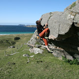
Lewis Bouldering


Sron Ulladale was most impressive and bone dry, though I saw no climbing parties about... amongst the giant boulders at the bottom I spooked a big cat (either that or a fox) and discovered a pair of green wellies and a frying pan if anyone wants them back? A particularly good swim is the 'jacuzzi pool' flowing out from the Waterboard dam on the walk-in... just beware sweeping vortex currents, I went round and round like a drowned fly in champagne until I could grab a rock to haul myself out spluttering and chastised of my boldness.

I'll post some bouldering news shortly, as well as sample pages of some of the new books in production at Stone Country... the new Font guide will be here soon!

Popular posts from this blog

The Lost Township of Grulin on Eigg

‘The Stony Place’ as it translates, the archaeological notes on the RCAHMS database for Eigg, state baldly the lost humanity of Grulin as early as an 1880 OS survey map: ‘…eighteen unroofed buildings, six enclosures and a field-system’. Now a scheduled monument and memorialised as a ‘depopulated settlement’, though it is not obvious if the verb is passive or aggressive, Grulin Uachdrach (Grulin Upper) is, like Hallaig on Raasay, a place of violent silence and resonance. Who lived here and why was the site abandoned? If it were not in Scotland, suspicions might fall to the climate, remoteness and apparent unsustainability of the stony place, a rabble of large rocks under the steep slopes of An Sgurr, but the carefully constructed walls tell us it was once a thriving township – the kilns, folds and blackhouse walls integrated with the giant boulders such as Clach Hosdail. In 1853 the whole of the village of Grulin, both upper and lower, housed fourteen families who were forced to l...

Timeline Walks of Scotland #Hallaig to Screapadal on Raasay

'Tha tìm, am fiadh, an coille Hallaig ...' Hallaig - the lost village of Raasay - is a powerful place. Arguably, it has become a shibboleth for the soul of Gaelic culture. To visit it, to just be there momentarily and feel the resonance of the place, is to know the fragility of place and home, of how kinship can be shattered and how loss can invade a land. Aptly, Hallaig is now a site of pilgrimage for those who value the universal lessons of history.  There are t errible reasons for the loss of Hallaig. Its silent mouths of abandoned shielings, the dumb sheep meandering amongst the ruins, whisper with Sorley MacLean's poetry. The place misses the sounds of day-to-day community, and all around the woods and burns and slopes this tough but rich landscape once made this a hardy paradise under the eastern cliffs of Raasay. Facing east to the dawn and overlooking the peninsula of Applecross and the berry-dark depths of the Inner Sound, the walk to Hallaig leads quietly...

Beinn Dòrain

           Viaduct and Beinn Dorain Once you cross the bealach under Beinn Odhar north of Tyndrum, the shapely peak of Beinn Dòrain is a visual fanfare to the Highlands. The mountain and its environs are richly detailed in the poet Duncan Ban MacIntyre’s poem Moladh Beinn Dòbhrain (‘In Praise of Beinn Dòrain’). [i] Its symmetrical convexity, deeply gullied flanks like pencil sketch-marks, and stern domed summit, make this a moment to instinctively reach for the camera. It is a steep but invigorating mountain to walk, which is more leisurely explored from its eastern corries, though the traditional ascent from Bridge of Orchy, up to the toothed ‘Am Fiachlach’ ridge quickly brings fine views from the heart of the Central Highlands, encompassing Cruachan in the west to Lawers in the east and the Mamores to the north. If you were set the task to name the features and character of this mountain, before a Gaelic toponymy, you may have come up with a similar voc...