
Muchalls Shore

Thanks to Stuart Stronach for pics of an exciting new venue: Muchalls Shore, south of Portlethen. Stuart reports:

Thankyou Mister Limpet V1

"It’s a few miles south of Portlethen – a broad pebbly beach with assorted boulders, craglets and pinnacles that now offers nearly 100 problems, mostly very easy but with a few up to V5. As such, it will hopefully attract those who find the Portlethen circuit a little too intense, and/or those new to bouldering. The mostly friendly landings also make a pleasant change from the boulders and rocks on other coastal spots. That said, there are a few problems which require a ‘shallow water soloing’ mentality, including Chris Fryer’s Smile Around the Face.


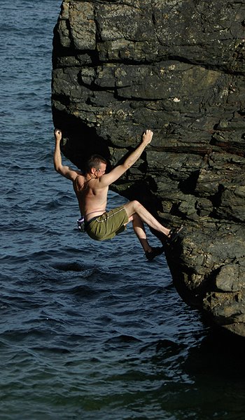
Smile Around the Face V2

Downsides? Well, it’s more tidal than Portlethen, so barnacles can be a problem when the tide is out, and the problems are spread out over a larger area.


Potential for more problems? The area immediately north of the current developments is a complex arrangement of through-caves and arches which provide some very steep rock. Some of it is crumbly, some of it is greasy, but there are areas which could yield some much harder problems than have currently been climbed. There is also potential for some sport routes to be done on the landward face of the massive stack/headland out to sea from the descent path.

The main developers have been myself, Amanda Lyons, Chris Fryer and Rowie Beaton, with the odd contribution from Ben Tye, Andy Inglis, Matthew Bernstein and Dave Bruce.

I’ve put together a wee guide to the areas which Tisos are selling for me – full colour topos plus text descriptions of every problem plus photo illustrations throughout."
GR
903916 - 903913

Popular posts from this blog

The Lost Township of Grulin on Eigg

‘The Stony Place’ as it translates, the archaeological notes on the RCAHMS database for Eigg, state baldly the lost humanity of Grulin as early as an 1880 OS survey map: ‘…eighteen unroofed buildings, six enclosures and a field-system’. Now a scheduled monument and memorialised as a ‘depopulated settlement’, though it is not obvious if the verb is passive or aggressive, Grulin Uachdrach (Grulin Upper) is, like Hallaig on Raasay, a place of violent silence and resonance. Who lived here and why was the site abandoned? If it were not in Scotland, suspicions might fall to the climate, remoteness and apparent unsustainability of the stony place, a rabble of large rocks under the steep slopes of An Sgurr, but the carefully constructed walls tell us it was once a thriving township – the kilns, folds and blackhouse walls integrated with the giant boulders such as Clach Hosdail. In 1853 the whole of the village of Grulin, both upper and lower, housed fourteen families who were forced to l...

Timeline Walks of Scotland #Hallaig to Screapadal on Raasay

'Tha tìm, am fiadh, an coille Hallaig ...' Hallaig - the lost village of Raasay - is a powerful place. Arguably, it has become a shibboleth for the soul of Gaelic culture. To visit it, to just be there momentarily and feel the resonance of the place, is to know the fragility of place and home, of how kinship can be shattered and how loss can invade a land. Aptly, Hallaig is now a site of pilgrimage for those who value the universal lessons of history.  There are t errible reasons for the loss of Hallaig. Its silent mouths of abandoned shielings, the dumb sheep meandering amongst the ruins, whisper with Sorley MacLean's poetry. The place misses the sounds of day-to-day community, and all around the woods and burns and slopes this tough but rich landscape once made this a hardy paradise under the eastern cliffs of Raasay. Facing east to the dawn and overlooking the peninsula of Applecross and the berry-dark depths of the Inner Sound, the walk to Hallaig leads quietly...

Scotland's Iconic Mountains #Broad Law

BROAD LAW The rolling hills east of the modern motorway of the M74 hold much more character and history than they appear from the west, where they are now flanked by forestries of spruce and wind-farms. In medieval times this was a Scottish royal hunting ground – the ‘Ettrick Forest’.  Further east towards the Tweed valley, there are echoes of a deeper Scottish history in the border towns of Hawick, Selkirk, Galashiels, Peebles and Kelso, all on the banks of the historic River Tweed and famous for their medieval forts and abbeys.  Looking west from Broad Law to the monoculture forestry and wind-farms of 21st C Scotland This range of hills, along with the northern flanks of the Cheviot hills, marks the geographical transition to the once-contested border with Northumberland, with its high pass over Carter Bar on the A68. The more useful sense of boundaries are suggested not by the roads but by the watersheds: to the north the waters drain into the River Cly...