
Cammachmore - New Aberdeen bouldering


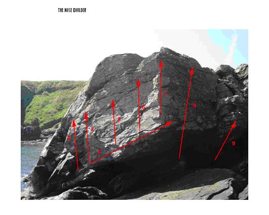
Having been partly developed by Tim Rankin but unreported, over the summer Tom Kirkpatrick has further developed this schist bouldering venue. It has larger boulders than Portlethen, meaning some highball finishes and problematic landings, as well as some deep-water soloing possibilities, but the best problems are safe and on good rock and there are some satisfying traverses. Tom will put a topo on the wiki at www.scottishclimbs.com


Tom's description:

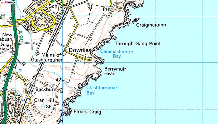
Cammachmore Bay Bouldering

Chilled out bouldering venue, just south of Craigmaroinn. The Bay gets all the sun going and nesting puffins can be seen on the cliffs above and seals and porpoises in the water below. The climbing is on a variety of large and small blocs and walls on beautiful water washed schist. A good spread of grades is available. The only draw back is that mats and good spotters are definitely required.

The boulders can be approached in two ways. At very low tide by heading straight down the path towards the sea from the turning area at Downies, turning left at first col on the ridge to Gorillas Head, heading toward obvious ‘yellow headed’ boulder, then walking round the bay past The Dark Side boulders to the main area. If not possible then follow costal path north briefly before heading straight down vague path in the centre of headwall of bay. Time 3-5 mins.

Popular posts from this blog

The Lost Township of Grulin on Eigg

‘The Stony Place’ as it translates, the archaeological notes on the RCAHMS database for Eigg, state baldly the lost humanity of Grulin as early as an 1880 OS survey map: ‘…eighteen unroofed buildings, six enclosures and a field-system’. Now a scheduled monument and memorialised as a ‘depopulated settlement’, though it is not obvious if the verb is passive or aggressive, Grulin Uachdrach (Grulin Upper) is, like Hallaig on Raasay, a place of violent silence and resonance. Who lived here and why was the site abandoned? If it were not in Scotland, suspicions might fall to the climate, remoteness and apparent unsustainability of the stony place, a rabble of large rocks under the steep slopes of An Sgurr, but the carefully constructed walls tell us it was once a thriving township – the kilns, folds and blackhouse walls integrated with the giant boulders such as Clach Hosdail. In 1853 the whole of the village of Grulin, both upper and lower, housed fourteen families who were forced to l...

Timeline Walks of Scotland #Hallaig to Screapadal on Raasay

'Tha tìm, am fiadh, an coille Hallaig ...' Hallaig - the lost village of Raasay - is a powerful place. Arguably, it has become a shibboleth for the soul of Gaelic culture. To visit it, to just be there momentarily and feel the resonance of the place, is to know the fragility of place and home, of how kinship can be shattered and how loss can invade a land. Aptly, Hallaig is now a site of pilgrimage for those who value the universal lessons of history.  There are t errible reasons for the loss of Hallaig. Its silent mouths of abandoned shielings, the dumb sheep meandering amongst the ruins, whisper with Sorley MacLean's poetry. The place misses the sounds of day-to-day community, and all around the woods and burns and slopes this tough but rich landscape once made this a hardy paradise under the eastern cliffs of Raasay. Facing east to the dawn and overlooking the peninsula of Applecross and the berry-dark depths of the Inner Sound, the walk to Hallaig leads quietly...

Scotland's Iconic Mountains #Broad Law

BROAD LAW The rolling hills east of the modern motorway of the M74 hold much more character and history than they appear from the west, where they are now flanked by forestries of spruce and wind-farms. In medieval times this was a Scottish royal hunting ground – the ‘Ettrick Forest’.  Further east towards the Tweed valley, there are echoes of a deeper Scottish history in the border towns of Hawick, Selkirk, Galashiels, Peebles and Kelso, all on the banks of the historic River Tweed and famous for their medieval forts and abbeys.  Looking west from Broad Law to the monoculture forestry and wind-farms of 21st C Scotland This range of hills, along with the northern flanks of the Cheviot hills, marks the geographical transition to the once-contested border with Northumberland, with its high pass over Carter Bar on the A68. The more useful sense of boundaries are suggested not by the roads but by the watersheds: to the north the waters drain into the River Cly...